
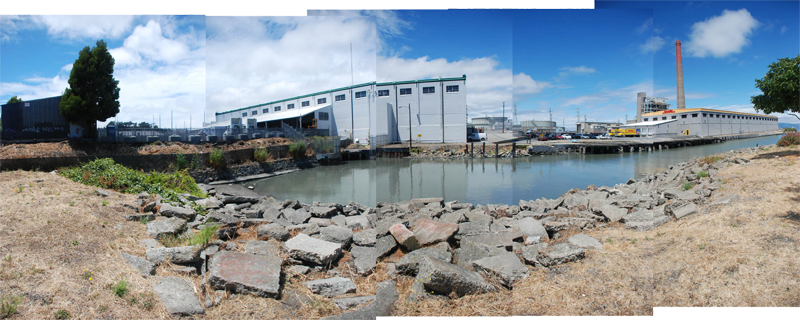
WARM WATER COVE is a 1.85 acre public park located in the Central Waterfront where 24th St meets the water. The park has picnic tables, a small walking trail and spectacular views of the bay. Despite its isolation and adjacency to several industries, Warm Water Cove Park has the potential to become a vibrant public space along the waterfront.
The former power plant to the north of the park was shut down in 2011 and awaits remediation. GreenTrustSF, a neighborhood non-profit, stewards the park running clean up and gardening days throughout the year. Proposals for the site include adaptively reusing the historic warehouses to the north of the park, the creation of a public plaza and a BMX park. For a more detailed vision of its potential future, see Mike Ernst’s 2007 report: Envisioning Warm Water Cove
HISTORY
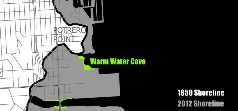
The area around Warm Water Cove developed during the industrialization of the waterfront in the 19th century. Claus Spreckels, a prominent industrialist with sugar and railroad enterprises, purchased a site along the south shore of what was then Potrero Point in 1881 and began construction of the California Sugar Refinery, later named the Western Sugar Refinery. It was one of the top five employers in the Dogpatch until the early 1950s, employing 1,000 workers at its peak.[1] The buildings to the north of the cove are warehouses from the Spreckles refinery still standing today. See FoundSF.org and Pier70sf.org for a fuller account of the of the legacy of Spreckles in San Francisco.
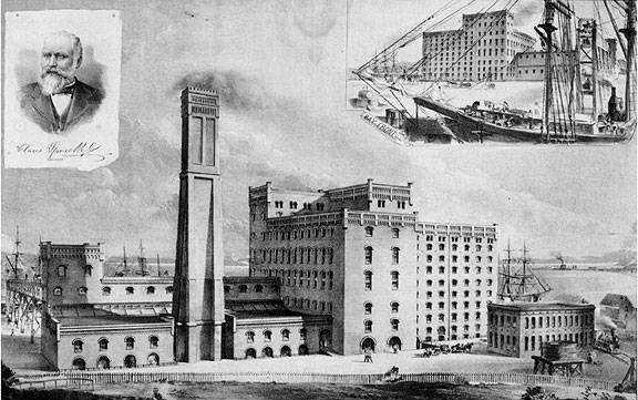
Image: Spreckels' Sugar Factory c. 1890, Bancroft Library, courtesy of FoundSF.org
To the north of the Spreckles refinery, the City Gas Company Works, a forerunner of PG&E, constructed a large power house to supply gas for lighting to the city. This site had been developed previously as a gunpowder manufacturer, taking advantage of what was then a remote site from the populated downtown to the north.[2] This site later became home to the Potrero Power Plant, operated by the Mirant Corporation until 2011 when it was shut down after great pressure from community members and local leaders. To replace the power generated by this plant, a cable runs under the bay and carries power generated in the East Bay in Pittsburg back to San Francisco. The transformer station along Illinois St converts that power for use in the city.
For many years, Warm Water Cove, once known as 'Toxic Tire Beach' was home to an extensive display of graffitti. The graffitti was cleaned up by the city in 2007 in a move that was protested by several local graffitti artists.[3] The Port, SF Department of Public Works and community volunteers pulled out many of the old tires from the tidelands, cleaned the grounds of brush and trash, and repaved the paths. The park is now home to several native plant and wildflower gardens that GreenTrustSF and the Port continue to support with work parties and clean-up days.[4]
- REFERENCES
- Christopher VerPlanck, "Dogpatch Historical Context," http://pier70sf.org/dogpatch/DogHistSig.htm
- Ibid.
- Jeanne Alexander, "Warm Water Cove Update: A Fascinating Document Explains Why the Graffiti is Still Gone," Winter 2007, http://sfcitizen.com/blog/2010/04/07/warm-water-cove-update-a-fascinating-public-document-explains-why-the-graffiti-is-gone/ and documented in Mike Ernst's "Envisioning Warm Water Cove," 2007
- Adapted from "Warm Water Cove" http://bluegreenway.org/parks-sites/
- IMAGE CREDITS
- Image: Spreckels' Sugar Factory c. 1890, Bancroft Library from http://foundsf.org/images/c/ca/Spreckels-sugar-factory-beneath-Potrero-Hill.jpg in "Sugar Palace," http://foundsf.org/index.php?title=Sugar_Palace
AMENITIES

ADDITIONAL IMAGES